AARP’s Guide to Death Valley National Park
The California oasis is huge, dry, often brutally hot — and absolutely worth a visit

Getty Images
Hottest place on Earth. Lowest elevation in North America. Driest of all national parks.
Death Valley National Park (DVNP), in southeastern California, is a land of superlatives. Its name alone, gifted by a group of Gold Rush hopefuls who lost one of its party while crossing the valley in the mid-1800s, suggests legendary status — a place to be admired, respected and perhaps even slightly feared.
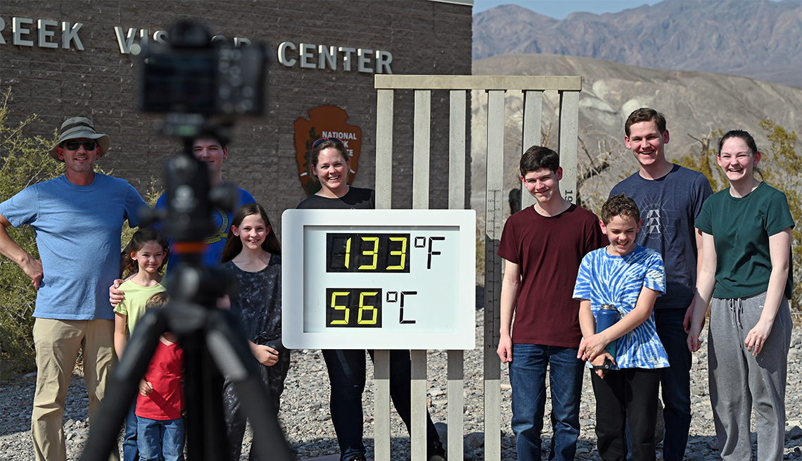
And perhaps it should be, to a degree. While the title for hottest place on Earth is a matter of some debate, temperatures soar in Death Valley’s aptly named Furnace Creek each summer, resting rather uncomfortably in the 120s, threatening to tip over 130 to set a new world record. In this type of heat, merciful breezes don’t exist; instead, wind hisses at any bit of exposed skin, burning as it passes. It’s a reputation that, coupled with the national park’s name, has kept visitation relatively low in comparison with more popular parks, such as the Grand Teton or Joshua Tree. Yet, with nearly 3.5 million acres to explore, it’s the largest national park outside of Alaska — and a fantastic place to explore, particularly in winter.
Nearly the entirety of Death Valley is designated wilderness, with 1,000 miles of paved and dirt roads connecting towering sand dunes, crusty salt flats and craggy peaks. They create some of the country’s most extreme vertical rises, the faces of which are dotted with remnants of a brief boom-and-bust mining history. This is the ancestral home of the Timbisha Shoshone people, whose village still resides in Furnace Creek, and many of the sites — including Eagle Borax Works, the Panamint Range and Ubehebe Crater — are considered culturally important and/or sacred. Please use discretion and show respect when visiting.
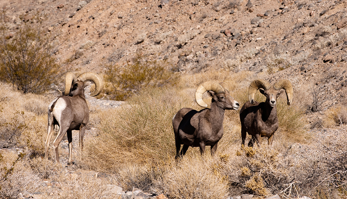
Bighorn sheep camouflage themselves against the badlands along the 120-mile basin, while desert kit foxes, kangaroo rats (who don’t need to drink any water in their entire lifetimes!), bobcats, jackrabbits and coyotes press tracks into the delicate sand.
While summer may bring devastatingly high temperatures, that shouldn’t overshadow other seasons, when warm days give way to cool stargazing under an open sky, unmarred by anything but shooting stars and the largest meteors you’re likely to see anywhere.

Getty Images/AARP
Location: Death Valley, California
Acreage: 3,422,024
Highest peak: Telescope Peak, 11,043 feet
Lowest point: Badwater Basin, 282 feet below sea level
Miles/number of trails: 94 miles, with 21 trails
Main attraction: Badwater Basin, the lowest elevation in North America
Entry fee: $30 per vehicle, valid for one week
Best way to see it: From a reliable 4x4 vehicle that can take you from point to point along U.S. Rou 190.
Best time to go: October through April provide cool enough weather to camp and hike at low elevations in the park. Wildflowers bloom on the valley floor from mid-February through mid-April. After that, flowers remain at higher elevations until June.
COVID-19 Update: Consistent with CDC recommendations, the National Park Service requires people who aren’t fully vaccinated to continue to wear masks indoors and in crowded outdoor spaces. Visitor centers are open. Check for updates at nps.gov/devaor call 760-786-3200.
Getting There
The small airport in Furnace Creek, near the center of the park where the elevation dips toward its lowest point, is open only to private airplanes, so most visitors arriving by air fly into Las Vegas, 106 miles east of the park, and home to the largest nearby commercial airport.
Death Valley is different from other national parks in that there are multiple entrances, none of which have ranger booths; rather, all roads lead to the main thoroughfare, U.S. Route 190, and eventually the Furnace Creek Visitor Center, which serves as the park’s hub. Here, you can pay your park fee, collect informational handouts (newsletter, maps, etc.), speak with rangers, and view a 20-minute video that details the park’s history. About 24 miles northwest on the highway lies the Stovepipe Wells Ranger Station, a modest and irregularly staffed building (with automatic payment machine to collect fees if there’s no one there) adjacent to a general market, bookstore and gas station.
Safety
Inside the park, you’ll find restroom facilities all along 190, making pit stops easy at the park’s main attractions. Not so with fuel stops, however: There are only two gas stations within the park, in Furnace Creek and Stovepipe Wells, near the primary western entrance. The main visitor center and hotels offer Wi-Fi, but cell service is spotty at best and cannot be relied upon for communication.
The rule of the road in Death Valley? Be prepared for emergency situations since the starkly beautiful landscape can turn deadly due to soaring temperatures and rough terrain. Plus, there’s no promise even during high season of passersby stumbling upon you to lend a hand should something go wrong. For these reasons, bring extra water and snacks in your backpack and vehicle, check your tires before arrival, know where your spare tire is, and have a backup plan for communication (such as a satellite messenger or personal locator beacon) should you run into a situation in which you need help.
While the main highway is in great condition, the dirt and gravel roads that lead to some of the park’s most winning vistas have claimed countless tires from even the most prepared SUVs. Seriously consider opting for an in-park Jeep 4x4 rental from Farabee Jeeps, in Furnace Creek. The company regularly services its fleet of two- and four-seaters, which have all the rugged road capabilities you need in the park and come with satellite tracking so that should anything go awry — knock on wood — park pros will know your whereabouts. Farabee also offers guided tours, especially popular with visitors traveling by RV, who otherwise cannot access many of the park’s roads due to vehicle length restrictions.
Where to Stay and Eat
You’ll find plenty of places to lay your head at night in DVNP between camping, rustic but comfortable lodging, and even upscale accommodations.
Oasis at Death Valley. Some 80,000 gallons of water flow to the surface daily in Furnace Creek, making this oasis the heart of the park’s action. Here, the two-property Oasis at Death Valley, a privately owned resort collection built in the 1920s by the Pacific Borax Company, later turned into a winter Hollywood getaway, playing host to notables such as Clark Gable and Ronald Reagan. Tucked into a hillside in Furnace Creek, the resort’s 88-room Inn at Death Valley, with a spring-fed pool (naturally heated to 84 1/2 degrees year-round), completed a $100 million renovation at the end of 2018, adding 22 private casitas (each with its own private golf cart for getting to and from the pool) and a spa to the lush grounds. Only the casitas and pool are open in summer.
Ranch at Death Valley. Just down the hill, Oasis's family-friendly sister property is open year-round. It offers 224 rooms and a mission-style town square shaded by towering date palms where visitors throughout the park gather to dine, drink and cool off. You’ll find a seasonal buffet, sit-down restaurant with mostly hearty fare (a standout: the generously portioned kale and goat cheese salad), a saloon with ice cold taps, an ice cream and coffee counter, and general store with everything from “I survived Death Valley” T-shirts to cans of cat food.
Stovepipe Wells Village Hotel. A second, smaller village lies 24 miles northwest in Stovepipe Wells, right next to Mesquite Flat Sand Dunes. The feel at Stovepipe Wells Village Hotel is less ranch-like, more motor lodge, with 83 modest rooms, a pool, seasonal chuckwagon-style dining, and 14 RV hookups. The market across the street has similar provisions as the Furnace Creek general store, but with more Death Valley-branded swag and the park’s cheapest gas.

travellinglight / Alamy Stock Photo
Furnace Creek Campground
Camping
First-come, first-serve campgrounds are abundant, but only the centrally located Furnace Creek Campground — just behind the visitor center and with 18 RV hookups and plenty of shady sites — takes reservations (Oct. 15-April 15, $22 per site, $36 per hookup,) available through recreation.gov. Mesquite Spring ($14 per site), Wildrose, Thorndike and Mahogany Flat (all three free) are at higher elevation, which means cooler temperatures that keep them open year-round as a result, but they’re also subject to higher winds and limited road access (a 25-foot length restriction on vehicles or 4x4 capabilities in some cases). These cooler campgrounds often fill up on weekends no matter the season, especially given that overnight temperatures down below in the valley regularly hover in the triple digits in summer.
The massive park welcomes dispersed camping (including car camping and backpacking), with some restrictions. You can set up one mile from any paved road, “day use only” area or developed area, but must avoid off-limit zones designated by the National Parks Service (trails, sand dunes and the valley floor between Ashford Mill and Mesquite Flat) and stay 100 feet from any water source — and, out of respect for the wild, no off-roading.

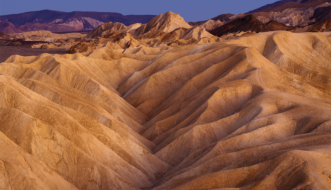
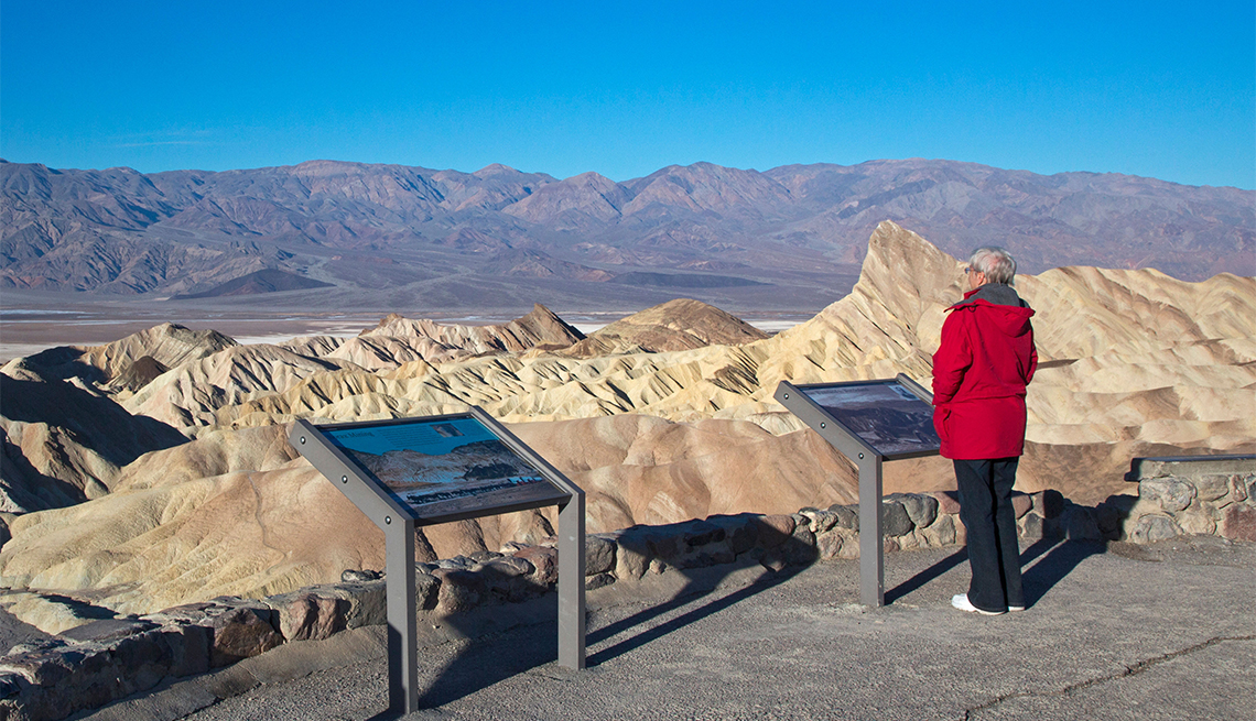
Dean Fikar/Getty Images
Zabriskie Point
Things to Do
Just as the Earth revolves around the sun, its presence guides activities in DVNP. Sunrise and sunset totally transform the park, turning sandy-hued vistas into brushstrokes of watercolor that shift from soft to fiery as the landscape’s natural minerals shine through. If you’re a photographer, take note: Plan your outposts for these times.
Though the park boasts more than 3 million acres to explore, NPS has done a good job of organizing points of interest, wrangling a handful into sites easily accessible by a typical vehicle, should a 4x4 rental be beyond your adventure budget. Each point can be appreciated by simply driving up or further explored on foot via trail or backcountry wandering.
They include:
Zabriskie Point. At sunrise, herds of onlookers flock to wheelchair-accessible Zabriskie Point, about 5 miles southeast of Furnace Creek, as first light trickles down the mountains that form the horizon, across the valley and finally to the hooked formation that this heavily photographed place is known for. Narrow trails lead down into the wash among the badlands and up along their ridges for sure-footed folks who’d like a different view.
Badwater Basin. Just 85 miles southeast of the highest point in the contiguous United States at Mount Whitney lies the continent’s lowest spot, 282 feet below sea level. Eighteen miles south of Furnace Creek, the paved Badwater Road and accessible boardwalk pours out into Badwater Basin, one corner of some 200 square miles of blueish-white salt flats composed of sodium chloride (also known as table salt), calcite, gypsum and borax that glow at sunset. You’re welcome to walk to the edge of the sturdy, even flats (1 mile, out and back), where polygon shapes form in the crust, creating the characteristic honeycomb veins that snake the surface as though they were Earth’s very wrinkles. To fully appreciate how low you really are, look back to the Black Mountains above the parking lot. High up the cliffs, there’s a sign marking sea level — you’re nearly 300 feet below it.
Artists Drive. Also off Badwater Road, a 9-mile one-way paved detour loop known as Artists Drive hugs the base of the Black Mountains, draping dramatically over orange hills and badlands and detouring into a small parking lot from which you can see Artists Palette, a display of iron oxide and chlorite-rich volcanic deposits that turn the landscape into a Jackson Pollock splash of color, particularly at daybreak and last light.
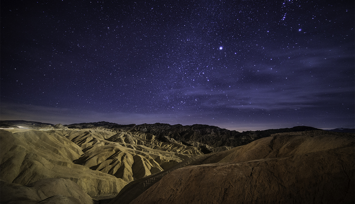
Dantes View. More than a mile above, Dantes View overlooks Badwater Basin, its vast salt flats morphing into wispy clouds with the bird’s-eye perspective. The easy, paved drive passes through fields that blossom with wildflowers in the spring, carrying you 5,575 feet up to a wide lookout with benches, a couple moderate trails, and wild views all around. By day (especially sunrise or sunset, but really, it’s spectacular at any time), you’ll feel as though you’re on the edge of the world, and by night, avid stargazers look skyward as the Milky Way unravels with exceptional visibility on the new moon, or downward into the basin when full, the moonlight illuminating the salt beds with iridescence.
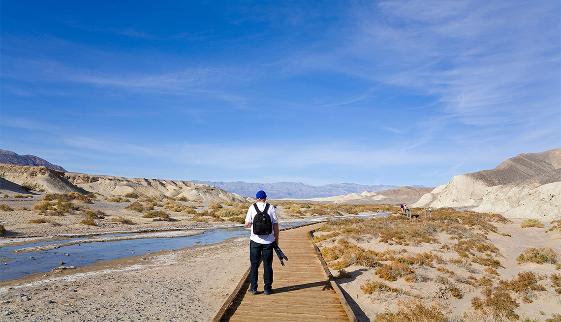
Salt Creek. Heading west on 190, signs for Salt Creek point you toward one of the last remnants of the valley’s previous life as a massive lake. When it dried up 10,000 years ago, the lake evolved from freshwater to salt, and the ancient pupfish — a tiny, bright blue swimmer found nowhere else in the world — evolved with it, adapting in order to survive in water temperatures that can range from near freezing up to nearly 107 degrees. Visit the half-mile ADA-accessible boardwalk loop November through May, when water flows through the wetlands and encourages the pupfish to spawn come springtime.
Mesquite Flat Sand Dunes. The highway curves around Mesquite Flat Sand Dunes near Stovepipe Wells, with a wide parking lot that offers remarkable views on its own. But plan on arriving before sunrise to walk the dunes after they’ve had time to cool off under the night sky. Most people stay within the first couple valleys, but you’ll be rewarded with solitude by hiking straight out 10 or 15 minutes, passing low juniper shrubs and gnarled mesquite trees (a resource for Timbisha Shoshone for centuries) that blossom in bright yellow flowers and green leaves each spring. There, you’ll be surrounded by soft ripples of sand unmarred by tracks, unless laid by a lizard, sidewinder or kangaroo rat. The tallest dune may not look far, but it’s a solid mile out and can take upward of two hours to get there and back. While birds are scarce in this part of the valley, it’s common to see flyovers from rare military craft in training, including massive triangular B-2 stealth bombers, which (as the name suggests) sneak up on you, so keep an occasional eye toward the sky to catch a glimpse.
Stargazing. The International Dark-Sky Association has designated Death Valley as a Gold Tier night sky, meaning there’s no better location for stargazing. The park’s rangers host nighttime programming in winter and celebrate the cosmos each spring at the annual multiday Dark Sky Festival. But you can enjoy the explosive display any time of year from the rangers’ favorite spots, including Mesquite Flat Sand Dunes, Harmony Borax Works (a historic mining site 1 mile west of Furnace Creek) and Badwater Basin.
Golf. Death Valley may seem an unlikely place for a golf course, but the links at Furnace Creek are notorious. The 18-hole, par 70 course is the lowest elevation game in the world at 214 feet below sea level and rated one of the toughest courses in America by Golf Digest due to the low barometric pressure, which seems to stop the ball in its tracks no matter how good your swing.
Gateway Towns
Because Death Valley has multiple entry points, it has no one definitive gateway town, and certainly no bustling one. But there are a few options for pit stops outside the park, including:
Baker, south of the park on Interstate 15 (where it meets the Mojave National Preserve), is a barely a one-street town but boasts the World’s Tallest Thermometer (or so it has been branded), a few run-down, vacant hotels and diners with vintage signage that make for a good quick photo, and the Mad Greek, a cafe known for its fresh strawberry shakes.
Beatty, across the border in Nevada, was founded in the early 20th century as a mining town, known by weary travelers for hot springs that recently shuttered. A few cute but somewhat random stops remain, such as the Sourdough Saloon and Atomic Inn, but by and large the massive Death Valley Nut & Candy Company is the place to hit for road snacks to suit any sweet tooth.
Lone Pine to the west — the gateway to Mount Whitney, the Alabama Hills and Eastern Sierras — is the best-known among towns near the park. You’ll spot all manner of outdoor enthusiasts here, celebrating recent summits or planning future adventures. Alabama Hills Cafe & Bakery is a favorite for fruit pie should you be peckish. If you don’t have much time but want to explore the scenery more, see it on display at the Museum of Western Film History, which pays tribute to the 400-plus films and countless commercials shot in the area.

AARP Membership -Join AARP for just $12 for your first year when you enroll in automatic renewal
Join today and save 25% off the standard annual rate. Get instant access to discounts, programs, services, and the information you need to benefit every area of your life.
En Route
Death Valley Junction. Those flying in to visit the park generally come through Las Vegas, just two hours by car to Furnace Creek. Driving west on Route 160, look for the Amargosa Opera House at Death Valley Junction, about five miles after crossing the Nevada-California state line. The junction itself is on the National Register of Historic Places and offers a modest collection of early-20th-century buildings, the white and bright-blue Amargosa theater and hotel among them. The Amargosa was originally built in the 1920s by a mining company but was taken over in 1967 by the late Marta Becket, a performer whose passion (and elbow grease) gave the opera house new life. While COVID-19 has temporarily paused performances, the hotel is open and accepting reservations.
China Ranch Date Farm. If you’re driving up through Baker, take U.S. Route 127 north to the China Ranch Date Farm, just south of Tecopa. Located in the midst of a desert oasis, the farm is open daily 9 a.m.-5 p.m. Visit for fresh dates (including proprietary varieties) and a richly complex history that includes the area’s Indigenous nations, a 19th-century Chinese miner and early pioneers.
Shoshone. Continuing north on California state Route 127, stop in Shoshone at the Shoshone Museum to learn about those whose ancestral homelands you’re about to explore. At the Charles Brown General Store across the street, stock up on supplies and browse locally made goods.
- |
- Photos
Hannah Lott-Schwartz is a San Diego–based journalist telling stories for National Geographic Traveler, Fortune, TIME, and others.